Introduction
There's a moment on the Harihar Fort trek that stops most people in their tracks. You round a bend on the trail, look up, and see a nearly vertical staircase carved directly into a cliff face, climbing straight up into the sky. That's the sight that has made Harihar Fort, also known as Harshagad, one of the most photographed and talked-about fort treks in Maharashtra.
Located in the Trimbakeshwar range of Nashik district, this fort isn't just famous for its dramatic rock-cut steps. It carries centuries of history, from the Yadava dynasty through the Mughals and the British, and offers some of the best panoramic views in the Sahyadris.
This guide covers the genuine history behind Harihar Fort, what the trek actually involves, and the rules every visitor needs to follow to keep this trail safe and well-preserved.
Table of Contents
- Where Harihar Fort Is Located
- The History of Harihar Fort
- The Famous Rock-Cut Staircase
- What's at the Summit
- Trek Routes and Base Villages
- How to Reach Harihar Fort
- Difficulty Level and Who Should Attempt It
- Best Time to Visit
- Rules and Etiquette You Must Follow
- Practical Tips
- Nearby Attractions
- Frequently Asked Questions
Where Harihar Fort Is Located
Harihar Fort sits in the Trimbakeshwar range of the Western Ghats, in Nashik district, Maharashtra. It stands at an elevation of approximately 3,676 feet (1,120 meters) above sea level, roughly 40 kilometers from Nashik city, 48 kilometers from Igatpuri, and 13 to 22 kilometers from Trimbakeshwar, depending on which base village you start from.
The fort was originally built to guard the ancient trade route through Gonda Ghat, which connected the Nashik region with Gujarat and western Maharashtra, making it a strategically important watchtower in its time.
The History of Harihar Fort
Harihar Fort, also referred to as Harshagad, Harshgad, or Harihargad, was constructed during the Seuna (Yadava) dynasty, a medieval kingdom that ruled large parts of Maharashtra between the 9th and 14th centuries before the Khilji invasion brought their reign to an end.
The name "Harihar" itself is a compound of Hari (a name for Vishnu) and Har (a name for Shiva), reflecting the syncretic religious traditions of the region and possibly the deities once worshipped at the fort.
Following the Yadava period, the fort came under the control of the Ahmadnagar Sultanate. In 1636 CE, Harihar Fort was handed over to the Mughals along with Trimbakgad, Tringalwadi, and several other nearby forts. Later, in 1818, the fort was among 17 strongholds that surrendered to the British under Captain (later General) John Briggs, following the fall of Trimbak fort.
Today, the fort's rock-cut water cisterns, a small palace structure, and its legendary staircase remain as physical reminders of this long history.
The Famous Rock-Cut Staircase
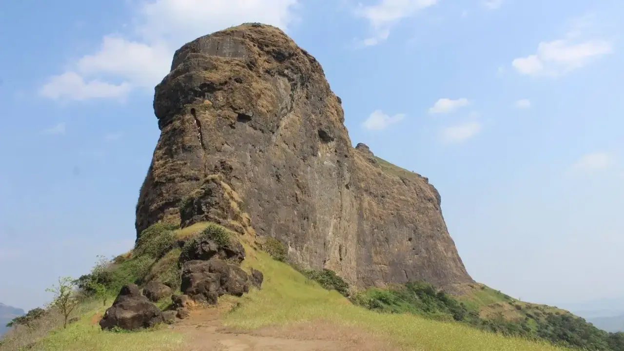
This is what Harihar Fort is genuinely known for. From the base village, the hill appears as a broad, rectangular mass, but this is an optical illusion. As you get closer, the fort reveals itself as a triangular prism of rock, with its three faces and two edges rising nearly vertical at around 90 degrees, while the third edge slopes at roughly 75 to 80 degrees.
The only way up is through a staircase carved directly into the rock face: a narrow, roughly one-meter-wide passage with hand-carved niches, rising to the summit at a near-vertical angle. Most sources count 117 steps in total, spanning close to 200 feet of near-vertical rock. This is the single most defining, and most demanding, part of the entire trek.
Because the staircase is narrow, exposed, and steep, it's the main reason Harihar Fort is consistently ranked among the most thrilling fort treks in Maharashtra, and also the main reason it demands real caution.
What's at the Summit
Once you've climbed the staircase, the summit rewards you with:
- A small temple housing idols of Lord Hanuman, Nandi, and Shiva
- A small pond with water that is generally considered potable
- The remains of a small palace structure with two rooms
- A set of rock-cut water cisterns along one side of the old palace, at least one of which holds drinkable water
- A saffron flag hoisted at the highest point of the fort
- A 360-degree panoramic view of the Trimbakeshwar mountain range, with Bhaskargad (Basgad), Anjaneri Fort, Brahmagiri, and Fani Dongar visible on a clear day
Trek Routes and Base Villages
There are two commonly used base villages for the Harihar Fort trek:
Nirgudpada (via Kotamwadi)
This is the more frequently used route. The entry point to the trek is opposite the Harihar Dhaba, close to the Nirgudpada bus stop. From Kotamwadi, the trail moves away from the village, crosses paddy fields, climbs gradually through bushy forest, and opens onto a ridge that connects directly to the fort. The trek from the base village is roughly 3 to 4 kilometers and takes about 2 to 3 hours one way, not counting the staircase climb itself. If you're new to fort treks, our navigation tips for Sahyadri fort treks guide is worth a read before you set out.
Harshewadi (via Trimbakeshwar)
This route is generally considered shorter and quicker than the Nirgudpada approach. Harshewadi is about 13 kilometers from Trimbakeshwar town. If starting from Mumbai, leaving by 4:30 AM gets you to this base by around 6:30-7:00 AM for a comfortable start.
How to Reach Harihar Fort
From Mumbai - Drive via NH 3 (Mumbai-Agra Highway) toward Kasara, continue past Kasara toward Igatpuri, then take the road toward Trimbakeshwar to reach Nirgudpada (approximately 150-165 km, roughly 4-5 hours by road) - By train: take a local or express train from Mumbai CST/Kasara toward Nashik Road or Igatpuri, then hire a taxi onward to your chosen base village
From Pune - Approximately 256-260 km by road, roughly 5.5 to 6 hours - By train, travel to Nashik Road, then hire a cab to Trimbak and onward to the base village
From Nashik - Nirgudpada is roughly 40-45 km from Nashik city, about 1 to 1.5 hours by road
Nearest Railway Stations - Kasara Railway Station: approximately 60 km from the base village - Nashik Road Railway Station: approximately 56 km from the base village
Important note on return transport: ST buses from both Nirgudpada and Harshewadi typically run only until around 5 PM, and frequency drops sharply after 3 PM. If you're relying on public transport, plan to complete your descent and reach the base village well before then, or pre-arrange a private jeep through your homestay.
Difficulty Level and Who Should Attempt It
The Harihar Fort trek is generally rated moderate to difficult. The approach trail itself, through forest and open ridgeline, is manageable for most reasonably fit trekkers. The real challenge is the final rock-cut staircase: narrow, exposed, and close to vertical, which demands confidence, steady balance, and a level head with heights. If you're weighing your options, our Harishchandragad trek guide covers a similarly demanding but very different kind of climb.
- Suitable for: trekkers with some prior hill-fort trekking experience and no fear of heights
- Not recommended for: absolute beginners, young children, or anyone with medical conditions affecting balance or cardiovascular fitness
- No forest department permission is required to attempt this trek, and it can be done independently without advance registration
Best Time to Visit
- Post-monsoon and winter (October to February): Generally considered the best window, with cooler, more pleasant weather and drier, less slippery steps
- Monsoon (June to September): The landscape turns lush green, streams appear along the trail, and the fort's back face is known for a striking reverse waterfall effect. However, the rock-cut steps become significantly more slippery and risky during this period, so extra caution is essential
- Many trekkers specifically avoid weekends during peak season to skip the crowd that builds up at the narrow staircase
Rules and Etiquette You Must Follow
Because the staircase is narrow and heavily trafficked on weekends, and because the fort holds genuine historical and religious significance, visitors are expected to follow these guidelines:
- Do not litter. Carry all your waste back down with you; there are no waste collection facilities at the summit.
- Avoid loud music or alcohol during the trek and at the fort.
- Respect the religious idols and small temple at the summit; this remains an active place of worship for locals.
- Avoid risky selfies or overtaking others on the staircase. The steps are narrow with sheer drops on either side, and impatience here has led to accidents.
- Start early to avoid crowding at the staircase, especially on weekends and holidays.
- Travel in a group or with an experienced guide if this is your first time attempting the climb.
- Be respectful toward local villagers at the base villages, whose homes and land you'll be passing through.
Practical Tips
- Wear trekking shoes with strong grip, especially important if attempting this during monsoon
- Carry a minimum of 2 liters of water per person, along with ORS, glucose, and a basic first-aid kit
- Pack high-calorie, ready-to-eat snacks; after leaving the base village, only a small stall on the plateau sells water and snacks
- Carry a valid ID card
- Quick-dry clothing is preferable over cotton, particularly for monsoon treks
- Carry at least ₹1,000 in cash, since the nearest reliable ATMs are in Nashik or Trimbakeshwar
- The nearest hospital is the Sub District Hospital in Trimbakeshwar; the nearest police station is Harsul Police Station, Trimbakeshwar
Nearby Attractions
Since you're already in the Trimbakeshwar region, these are worth combining with your trip:
- Trimbakeshwar Temple: One of the twelve Jyotirlingas of Lord Shiva, a major pilgrimage site roughly 13-22 km away
- Anjaneri Fort: Believed to be the birthplace of Lord Hanuman, rated easy to moderate, a good complementary trek
- Bhaskargad (Basgad) Fort: Another fort with comparable rock-cut steps, roughly 5-20 km away depending on route
- Brahmagiri Parvat: A sacred hill trek near Trimbakeshwar
- Dugarwadi and Shitkada Waterfalls: Scenic waterfalls close to the base villages, especially active during monsoon
Frequently Asked Questions
1. How many steps does Harihar Fort have? Most sources count 117 rock-cut steps, carved directly into the rock at a near-vertical angle of roughly 75 to 80 degrees, spanning close to 200 feet.
2. Is the Harihar Fort trek difficult? It's rated moderate to difficult. The approach trail is manageable for most fit trekkers, but the final rock-cut staircase is narrow, steep, and exposed, requiring confidence and good balance.
3. What is the history of Harihar Fort? The fort was built during the Yadava (Seuna) dynasty between the 9th and 14th centuries. It later came under Ahmadnagar Sultanate control, was handed to the Mughals in 1636, and eventually surrendered to the British in 1818 along with several other nearby forts.
4. What is the best time to visit Harihar Fort? Post-monsoon and winter, from October to February, offer the most pleasant weather and safer, drier steps. Monsoon offers lush scenery but makes the staircase considerably more slippery.
5. Do I need permission to trek Harihar Fort? No, the trek does not require permission from the forest department or tourism authorities, and can be done independently.
6. Which is the better base village, Nirgudpada or Harshewadi? Harshewadi via Trimbakeshwar is generally considered the shorter and quicker route, while Nirgudpada is the more commonly used and slightly longer approach.
7. Is Harihar Fort suitable for beginners? It's not ideal for absolute beginners or those with a fear of heights, since the final staircase is narrow, steep, and exposed with no side railing for much of its length.
8. What should I carry for this trek? At minimum: 2 liters of water, a first-aid kit, high-calorie snacks, a valid ID, cash, and footwear with strong grip.
Harihar Fort is one of those rare treks where the destination and the journey to it are equally dramatic. Its 117 rock-cut steps, carved centuries ago by hands we'll never know, remain one of the most striking pieces of medieval engineering in the Sahyadris. Layer that with the fort's genuine history spanning the Yadava dynasty, the Ahmadnagar Sultanate, the Mughals, and the British, and you get a trek that rewards both your legs and your curiosity.
Climb early, climb carefully, respect the staircase and the summit's religious significance, and Harihar Fort will give you one of the most memorable trekking experiences in Maharashtra.
Ready for Your Next Adventure?
Don't just read about it — come experience it. Browse our upcoming treks and book your spot with certified trek leaders, small groups, and everything organised for you.
🏷 Harihar Fort trek, Harshagad fort Nashik, Harihargad rock cut steps, Harihar Fort history
Be the first to comment on this post.